Fact Sheet
Exploration Phases
Mineral exploration is the process of identifying mineral deposits of economic interest within the earth’s crust which if successful may lead to the extraction or mining of the deposit.
Scope (Conceptual Model & Main Characteristics)
Mineral exploration is the process of identifying mineral deposits of economic interest within the earth’s crust which if successful may lead to the extraction or mining of the deposit.
Who
Mineral exploration is carried out primarily by the private sector but in some cases the public sector may also carry out this work. Private sector mineral exploration may be carried out by pure mineral exploration companies – often referred to as the ‘junior sector’; or by integrated mining companies which have both mining and exploration activities and are often referred to as ‘majors’ or ‘mid-caps’, depending on their market capitalisation. Junior companies commonly do not have an income stream and rely on funding from the Stock Market or private investors. Majors or midcaps would normally have an income stream from their mining operations and would fund exploration from the profits of these operations.
What
What commodity is explored for depends on the company (essentially their expertise) and the market (primarily price). Some companies explore for a single or limited range of commodities while others may explore for any or all minerals.
Phases
Four main exploration phases within an exploration programme may be identified:
- Ground selection;
- Target generation or reconnaissance;
- Target testing or investigation; and
- Deposit delineation.
Most exploration programmes do not complete all four phases and the programme may cease at the end of or within one of the phases. It has been estimated that the success ratio or rate of exploration is less than one percent (Table 1). While different writers describe the different phases of exploration differently they do come up with broadly comparable figures. Success rate in this case refers to the percentage of anomalies which become mines.
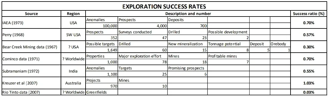
Table 1. Exploration success rates according to various authors.
Ground Selection
Ground selection is the process of selecting a region (this might be a geological domain or mineral province) or an area within the region to evaluate for mineral resources. Usually this is an office based phase but may include visits to the region under consideration. Normally publicly available information is compiled, integrated and evaluated in order to identify regions worthy of moving to the next phase.
Desired outcome: Regions or areas identified or a prioritised list developed for exploration.
Target Generation or Reconnaissance
Target generation or reconnaissance selects prospective locations and reduces a broad search to areas which are deemed to be most likely to host economic mineralization. Target generation may use any one of many techniques including prospecting, mapping, remote sensing surveys, geochemical surveys, geophysical surveys, or even drilling for geological information.
Desired outcome: Targets identified within the exploration area which will be tested by sampling.
Target Testing or Investigation
Target testing or investigation is the phase of an exploration programme in which the target is sampled and measured for its size, quality and the identification of features associated with the potential deposit, often considered essential according to the deposit model under consideration. The latter may include the presence of the sought after mineral, appropriate structures, or other associated features, such as alteration. Sampling may take the form of taking samples from the surface or underground, trenching, or drilling.
Desired outcome: Mineralization identified in sufficient quality and quantity that warrants further evaluation.
Deposit Delineation
Deposit delineation aims to quantify the amount (tonnage or volume) of mineral present within and the quality (usually grade) of a mineral deposit. This phase involves extensive and intensive sampling of the deposit, and assay or analysis of those samples so that a mineral reserve can be calculated. Such sampling may be carried out on the surface or underground but commonly involves much drilling. The actual calculation of the resource is highly regulated by codes or standards such as those developed by PERC (Pan-European Reserves and Resources Reporting Committee) for Europe, JORC (Joint Ore Reserves Committee) for Australasia or NI 43-101 (National Instrument) for Canada. These standards or codes, and others, are aligned to the CRIRSCO (Committee for Mineral Reserves International Reporting Standards) template for the reporting of reserves and resources.
Desired outcome: A mineral deposit with a well-founded calculation of the quantity and quality of the minerals in the deposit compliant with a recognised Code or Standard.
Following the successful outcome of the last phase other studies are carried out, such as geotechnical, metallurgical, marketing, planning, environmental, and social studies which support the development of evaluations of the mineral deposit. These evaluations include Preliminary Economic Assessments, Pre-feasibility Studies, Feasibility Studies, and Bankable documents. Once a Pre-feasibility or Feasibility Study has been carried out a mineral reserve may be reported.
Desired outcome: A mine which makes a profit.
Contexts of Use, Application Fields
- Contexts (e.g., environmental, economic, social assessment)
- Which types of stakeholder questions are concerned?
- Link to published studies that implement the method
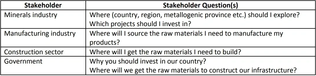
Mineral Exploration is an economic activity carried out by private industry and in some instances government agencies to identify the location of economically viable mineral deposits. Private industry normally means the minerals sector but may also include the manufacturing sector who may need a particular raw material to manufacture the products it fabricates. Mineral exploration consists of many activities and continually seeks to test an idea or hypothesis. If the outcome is sufficiently positive then the programme normally continues to the next activity or question. However, external factors, e.g. the price of a commodity, may change with time and alter the direction of the organization carrying out the exploration or its priorities.
The principal stakeholders and their question(s) for Mineral Exploration are:
Input Parameters
which parameters are needed to run the method
Mineral exploration commences with an idea or hypothesis. The idea often comes from experience, for example, a company may have experience in working with a particular type of deposit in one country and wishes to apply this experience and knowledge to another country. Or perhaps a company has developed a new exploration method and wishes to apply it to look for a particular type of deposit where it has been successful or wishes to apply it to another known type of deposit.
Alternatively, perhaps a company has an excellent track record in looking for a particular deposit type using a specialised conceptual model (the conceptual model may in this instance be considered to be a sophisticated idea).
Permission to Explore
Mineral exploration can thrive where there is excellent government, or other, geoscience information available to the exploration sector. However, excellent geoscience of itself is not sufficient. A thriving exploration sector also needs an excellent and transparent regulatory regime; government encouragement (not necessarily financial incentives); public understanding and approval; good infrastructure (access, telecommunications, water, and power); good services (technical and financial); a capable workforce; certainty (timeliness, legal, environmental, permitting, implementation, consistency, lack of duplication, corruption free, etc.); security; and political stability.
Type(s) of related input data or knowledge needed and their possible source(s)
- Which types of data are needed to run the method, from which sources could they come…
- Could be qualitative data or quantitative data, and also tacit knowledge, hybrid, etc.
Under this heading we consider topics that are relevant to Mineral Exploration but do not necessarily fit into the generic heading. This includes:
- Permission to explore
- Basic geographical and topographical data (maps)
- Geoscience data
- Software
Permission to Explore
The most basic requirement is permission to carry out exploration. This varies from jurisdiction to jurisdiction. It may mean obtaining a permit or licence to explore from a government, provincial or local authority. In some countries it may mean obtaining permission from a land or mineral rights owner. In addition, it may be necessary to obtain permission to carry out certain activities or to carry out activities in or near protected sites or certain material assets. There are too many jurisdictions across Europe for a comprehensive review of the permissions required to carry out exploration and suffice it to say that permission is required. The onus is therefore on the explorer to determine what permissions are required in the jurisdiction they are operating and to obtain them and ensure that they keep them in good standing.
Basic Geographical and Topographical Data (Maps)
The most basic requirement is a geographical and/ or topographical map – sensu lato. In modern times topographical maps may be either hard copy (paper) or soft copy (digital). If the latter then software will be required to view, store and manage the maps. The scale of the maps required will depend on the stage at which the project is at and may be small scale (for example 1:250,000 for regional work) or large scale (for example 1:1,000, or larger, for deposit evaluation).
A topographical map may be a traditional map; satellite imagery; aerial photography; digital terrane (or elevation) models; or otherrepresentations of the land surface. Such maps are often used as base maps upon which information of interest is displayed.
Geoscience Data
Mineral Exploration does not require information or data to carry it out. However, it is greatly facilitated by prior reliable geological information and data. This prior information may come from government (commonly from Geological Surveys), exploration companies, universities, or the internet.
Government
Available datasets such as geochemistry, geophysics and boreholes (primarily from national or regional geological surveys) will also often be consulted to aid in interpretation of surface and sub-surface features and to generate exploration targets. Such information may also be available on an exclusive or non-exclusive basis from third part vendors. In addition, companies may enter into data exchange arrangements where seek to gain understanding and benefit.
Exploration Companies
In some jurisdictions it is mandatory for exploration companies to report their work to a government agency. Subsequently these reports may be made available either after a specified period or upon the relinquishment (or withdrawal) of the exploration permit.
Universities and Research Institutes
The geoscience or mining departments of universities and research institutes often contain much information of interest to the exploration community. This primarily relates to detailed geological knowledge of an area or deposit type, and also geochemical and geophysical surveys.
It is common practice for exploration companies to sponsor student projects (up to and including post-doctoral projects). Such projects are carried out on a mutual interest basis with the university providing expertise and the exploration company financial support.
Internet
Modern exploration makes use of the wealth of information available over the internet. There are many sites dedicated to providing basic information such as http://www.minerals4eu.eu/ and individual geological surveys normally have an abundance of data available much of it free to download. There are also information services available from commercial vendors with some available for free with more available for purchase.
Software
Modern day topographical and exploration data is often stored, manipulated, processed, visualised and displayed in Geographical Information Systems (GIS). In addition, specialist software for geoscience data sets (geological, geochemical, geophysical and remotely sensed data) is often used to process, interpret and visualise, and display information and data as well as to generate new insight and knowledge.
Model used (if any, geological mathematical, heuristic…)
- e.g., geological model for mapping
- e.g., mathematical model such as mass balancing, matrix inversion, can be stepwise such as agent -based models, dynamic including time or quasidynamic specifying time series…
- Can also be a scenario
Different types of model are used in mineral exploration. As referred to above often times an exploration programme is guided by reference to a particular model of the type of mineralization or commodity being sought, e.g. a porphyry copper deposit model. This is often referred to as a genetic model. A second type of model would be a model that guides the exploration – the exploration model.
This sort of model takes features from the genetic model which can be observed or measured. In our porphyry copper model example the geologist may look for the signature alteration that accompanies all such deposits. These would be the features that would be looked for in the first instance. Another type of model relates specifically to the geological situation in the area under consideration and may be termed the conceptual exploration model or simply the conceptual model. It would combine the known geological features of the area and the exploration guides being sought. These may be portrayed in a simple three dimensional cartoon highlighting the salient features. This model would be constructed from the known (or presumed) geology, existing maps, field observations and/ or remote sensing. It is often this model which is tested throughout the exploration process.
System and/or Parameters Considered
- The system can be described by its boundaries. These can refer to a geographic location, like a country, or a city, the time period involved, products, materials, processes etc. involved, like flows and stocks of copper, or the cradle-to-grave chain of a cell phone, or the car fleet, or the construction sector, or the whole economy…
- Parameters could possibly refer to geographic co-ordinates, scale, commodities considered, genesis of ore deposits and others…
Boundaries
In terms of boundaries, exploration may have national, geological or permit boundaries.
National boundaries
Exploration may be restricted to a single jurisdiction as regulations generally vary from one country to another. However, geology does not recognise the political borders of countries and favourable geological features and lithologies cross from one jurisdiction to another. In such cases exploration companies may take out exploration permits on either side of the political border.
Geological boundaries
Geological boundaries on the other hand may define the area of interest of the exploration company. If a company is interested in exploring for carbonate hosted zinc-lead deposits then the area being explored should be underlain by such rocks and not volcanic rocks, for example. The change from one rock type to another may form the boundary of the system. However, rock type is not the only geological boundary. Other geological boundaries include: metallogenic provinces; structural style; age of rocks and age of mineralizing system.
Permit Boundaries
Often times the area being explored is constrained by the permit. The permit would normally have a map illustrating the area where exploration may be carried out by the permit holder or licensee. It may be that the ground adjoining the area under permit is another permit held by another explorer. Permit boundaries may be defined by rectangular coordinates or geographical features visible on the ground – depending on the jurisdiction. The size of individual permits may also vary from jurisdiction to jurisdiction.
Scale
Scale in this case refers to the size of the area over which exploration is being carried out. Scale depends on numerous factors including the financial resources available, target commodity or H2020 MICA PROJECT deposit type, time, and permit conditions. It may begin at a national level and then proceed to regional level targets which in turn may be reduced to targets at a local level.
Financial Resources
The magnitude of the exploration programme and its intensity ultimately depends on the financial resources available to the company. Often times the availability of funds is dependent on the success of a previous phase of exploration. If the previous phase was successful then it will be easier to justify additional expenditure than if there little or no success. But the availability of funds also depends on the current market conditions. For example, if the price for the commodity being sought decreases then it will be more difficult to justify further expenditure regardless of the success of previous phases.
Target Commodity or Deposit Type
Different commodities occur in deposits of different sizes. For example, iron deposits typically occur on a much larger scale than precious metal deposits. Therefore typically the area over which exploration for iron is carried out will normally be much larger than for, say gold deposits.
On the other hand the deposit type or commodity being sought may become fall out of favour – perhaps for an environmental reason and the exploration company may find it difficult to justify exploring for the deposit type to the investing community, the regulators, or its own management. An example might be uranium deposits.
Time
Exploration may take place over timescales as short as individual field seasons to as long as several decades, particularly when attempting to expand known deposits. Exploration around working mines is particularly important for long term and very long term planning – ranging up to tens of years
Regulations
Some jurisdictions require that the area under permit be reduced on a phased or planned basis. For example a permit holder may have to reduce the area of the permit after stated periods, by 50% after 5 years; by 90% after 10 years.
Time / Space / Resolution /Accuracy / Plausibility…
- To which spatio-temporal domain it applies, with which resolution and/or accuracy (e.g., near future, EU 28, 1 year, country/regional/local
level…) - For foresight methods can also be plausibility, legitimacy and credibility…
Conceptual models of the geology of a specific area need to be dynamic. Although the geology of an area rarely changes on the timescale of a human lifespan the uncovering of new evidence or a new or reinterpretation of the evidence may alter the conceptual model and hence the model may be updated and the exploration programme may be revised.
Spatial scale is discussed in the section headed “System and/or parameters considered”. The initial scale for target generation is unlikely to be the same one that is used to delineate an economic ore-body. Often a large scale target generation programme on a regional scale will create numerous smaller local scale target areas that can be investigated individually.
While high resolution and accuracy are important at all phases of exploration it is crucial for the deposit delineation stage. At this stage an estimate of the tonnage and grade of the deposit is made and a value may be put on the deposit. It is at this stage that major decision on whether to proceed with the development of the deposit may be made which may result in expenditure of hundreds of millions or billions of euros are made. Therefore the accuracy of the estimate is crucial. Accuracy is guided by reference to codes and standards often determined by the world’s Stock Exchanges. Most Stock Exchanges require the standard or code to be aligned to the CRIRSCO template. CRIRSCO is the Committee for Mineral Reserves International Reporting Standards and comprises representatives of organisations that are responsible for developing mineral reporting codes and guidelines in Australasia (JORC), Brazil (CBRR), Canada (CIM), Chile (National Committee), Europe (PERC), Mongolia (MPIGM), Russia (NAEN), South Africa (SAMREC) and the USA (SME).
Indicators / Outputs / Units
- This refers to what the method is actually meant for. Units are an important part but that is most of the time not sufficient to express the meaning. For example, the indicators used in LCA express the cradle-to-grave environmental impacts of a product or service. This can be expressed in kg CO2-equivalent. But also in €. Or in millipoints. Or in m2 year land use.
- For foresight methods the outputs are products or processes
The desired output from mineral exploration is ultimately the identification and delineation of an economically viable mineral resource which can then be mined. Each phase of exploration corresponds to a more advanced step along the path to an operating mine. Mineral resources are measured in terms of their mass or volume and a measure of quality which may be the grade or amount of a substance in the deposit, although standard units vary for different commodities.
Treatment of Uncertainty, Verification, Validation
- Evaluation of the uncertainty related to this method, how it can be calculated/estimated
Ore body validation is covered by the various CRIRSCO international reporting codes for mineral resources, e.g NI 43-101, JORC and PERC.
Main Publications / References
- e.g. , ILCD handbook on LCA, standards (e.g. , ISO)
- Can include reference to websites/pages
- References to be entered with their DOI
Bohmer, M. & Kucera, M. (2013). Prospecting and Exploration of Mineral Deposits (Developments in Economic Geology). ISBN 0444597875, 9780444597878
Kreuzer, O.P., Etheridge, M.A., and Guj, P., 2007b. Australian junior exploration floats, 2001-06, and their implications for IPOs. Resources Policy, v. 32, p. 159-182.
Related Methods
- List of comparable methods, their particularities…
- link to one or several other existing fact sheet(s)
Some Examples of Operational Tools (CAUTION, This List is Not Exhaustive)
- e.g., software… Only give a listing and a reference (publication, website/page…)
- Should be provided only if ALL main actors are properly cited
Key Relevant Contacts
- List of relevant types of organisations that could provide further expertise and help with the methods described above.
National and Regional Geological Surveys, Mineralogical and Geological Associations.