DRI TECHNOLOGY ASSOCIATES, LLC EXPLORATION SERVICES - Oil & Gas Mining-Precious Minerals, Rare Earth, Diamonds
Abstract
The ability to perceive the Earth up to a depth of 20,000 feet and locate natural resources with an accuracy of six inches, without any environmental impact, would revolutionize many fields and have profound implications.
Various techniques can be used to cover targets of interest. Different techniques have different resolutions and depth considerations. The choice of technique used and the cost of surveying and exploring with such techniques will vary depending on the terrain, political situation, environmental conditions, permitting and licensing, and funds available.
Interpretation of the data will be tasked to a geophysicist, geologist, or other specialist skilled and familiar with a working understanding of the location(s), environmental factors and ability to interpret the data and provide an adequate report in a timely manner:
1. **Mineral Exploration & Mining**: Companies could precisely locate mineral deposits, making exploration more efficient and lessening the need for exploratory drilling. This could transform the mining industry into a more precise and less wasteful endeavor.
2. **Oil and Gas Industry**: Accurate identification of oil and gas reservoirs would reduce the need for multiple test drills, saving money and reducing the environmental footprint of exploration.
3. **Environmental Conservation**: A non-invasive technique like this would drastically reduce the environmental impact of exploration, as there would be less ground disruption and less need for test drills.
4. **Economic Impact**: Nations with untapped or undiscovered resources could experience an economic boom, as they would have precise information on what's beneath their soil. This might shift global economic power dynamics.
5. **Archaeology**: Such a technology could assist archaeologists in pinpointing buried ruins or artifacts, aiding historical and cultural discoveries.
6. **Geology and Earth Science**: Beyond just resources, understanding the detailed structure of the Earth's subsurface would lead to advancements in the field of geology, possibly offering insights into seismic activity, plate tectonics, and the Earth's history.
7. **Water Resources**: Discovering underground reservoirs or aquifers could aid in water resource management, especially in regions facing water scarcity.
8. **National Security**: Countries might use this technology to ensure that no unauthorized or clandestine underground activities, like tunneling or underground facilities, are occurring within their borders.
9. **Ethical Implications**: With this ability comes the responsibility of using the knowledge ethically. For instance, a nation might discover valuable resources beneath the soil of a neighboring country or in disputed territories, potentially leading to conflicts.
10. **Property Rights**: Questions might arise about who has rights to the discovered resources, especially if they are located beneath private property or indigenous lands.
11. **Market Dynamics**: Knowledge of the exact location and quantity of resources can influence global market prices, potentially leading to market manipulation or strategic withholding of resources.
In conclusion, while the ability to accurately and non-invasively map the Earth's subsurface resources would be revolutionary, it would also come with challenges and responsibilities that society would need to address.
Summary of the Methods and Techniques
Geophysical techniques are routinely used in exploration programs to help delineate and map areas favorable for the target being pursued, determine or rule out drill locations, and maximize extraction over the lifetime of a mining or development project.
Geophysical techniques look far beneath the alluvial cover. They can be used to detect some minerals, indirectly detect others, and map structural geologic features indicative of the desired targets.
Using multiple, different geophysical methods at different stages of a project and integrating the geophysics results with geologic, geochemical, and borehole data are typically necessary to obtain the best information for making the high-stakes business decisions inherent in natural resource exploration and development.
Satellite and Airborne surveys are often used to initially scope out large geographic areas for economic minerals, followed by surveys conducted on the ground to narrow in on target locations and depths.
Direct and Indirect Detection of Minerals
Direct detection methods include the use of:
- Induced Polarization (IP) to Find Disseminated Sulfides,
- Magnetics to Delineate Magnetite-Hosting Rocks and
- Gravity and Electrical Techniques for Finding Massive Sulfides.
Examples of indirect detection methods include using IP techniques to detect pyrite in association with sphalerite and gold (both non-responders to IP geophysical techniques) and copper and molybdenum in porphyry systems.
Magnetics are routinely used to search for hydrothermal alteration in association with porphyry systems and can be used to map buried stream channels (magnetite sands) that might host placer gold.
Geologic Mapping
Gravity and seismic methods are often used to:
- Map faults and thickness of alluvial fill for Mapping Geology.
- Magnetics and seismic methods can be used to map structures and possibly the signatures associated with different rock types.
- Electrical methods may also be used to Map Alteration and Geology, depth to Bedrock, Structure, and different Rock Units.
Geothermal Capacity
Geothermal power generation requires high-fluid flow and high temperatures at an attainable depth.
Quantitative resource assessment can be derived by using:
- Magnetotellurics
- Seismic Reflection
- Gravity
Gravel Deposits
Exploration questions: How much gravel is here? Are there significant quantity variations between drill holes? How deep is it to the bedrock cutoff? How much might this property be worth? Quantitative resource assessment can be derived by using:
- Seismic Refraction
- DC Resistivity
Quality questions: How much clay is present in the gravel? Does the fine content vary between my sample points? What is the quality of the groundwater? How much due diligence is due? Quantitative resource assessment can be derived by using:
- Induced Polarization or other EM methods
Ore Bodies – Disseminated Sulfides
Where is the orebody? Where are the pyrites? Where is the barren zone? Where is the largest percentage of sulfides? Is this orebody economic? Quantitative resource assessment can be derived by using:
- Induced Polarization
- Gravity
- Magnetics
Ore Bodies – Massive sulfides
Where is the orebody? Where are the drilling targets, and what is their priority ranking? What is the size and shape of the orebody? Where did the orebody go when it disappeared? Quantitative resource assessment can be derived by using:
- Electro Magnetics
- DC Resistivity
- Magnetics
Radiometric Ore Bodies
Where is the uranium deposited? Where are the caves with radiometric minerals? Where are the faults that control ore deposition? Quantitative resource assessment can be derived by using:
- Borehole and or Grab Sampling Methods
- Scintillation Methods, Including Spectral Analysis
- X-Ray and Gamma Crystallographic Methods
- Seismic Refraction
- Resistivity
Lithology
Where to drill for uranium, gold or copper: What kind of rocks (sandstones or siltstones; granite or pegmatite; limestone or coal) are underground at relative depths? How do the rock types change laterally? Quantitative resource assessment can be derived by using:
- Induced Polarization and Other EM Methods
- Seismic Reflection
- Borehole Logging, Including Cross-Borehole Interpolation
Stratigraphy / Geologic Boundaries
Where to drill for natural gas and petroleum: What is the geologic structure? Which way do the strata dip? Where are the contacts between formations? Where are the faults folds? Quantitative resource assessment can be derived by using:
- Seismic Reflection
- Resistivity and IP Methods
- Pulse-Modified CSAMT
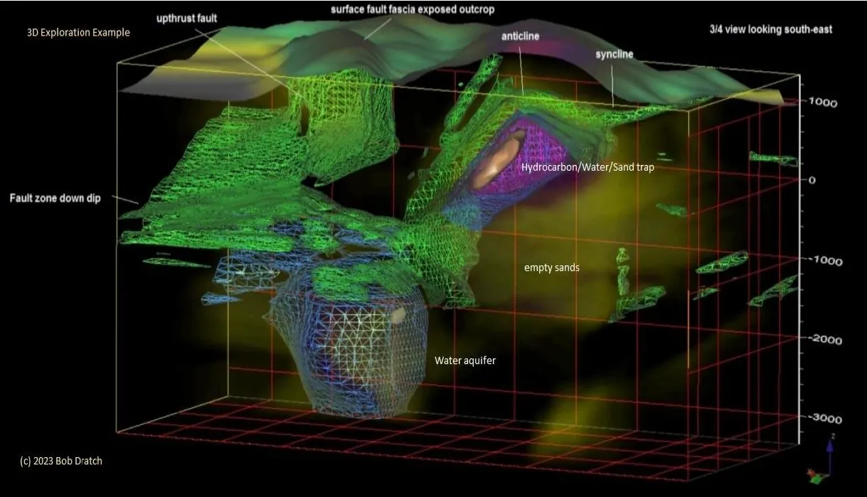
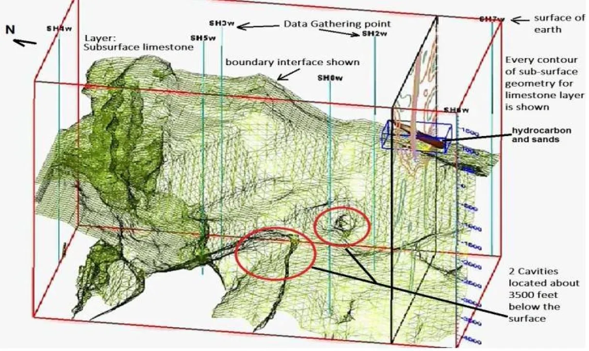
A product produced after inversion and rendering example can be a composite such as shown below: